Sustainable Tourism in Australia: do you love mountains and nature? Would you like to visit incredibly beautiful and less touristic areas?

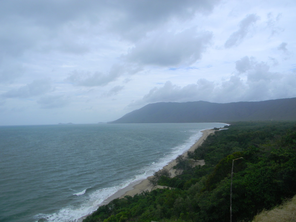
Although Australia is one of the driest continents on the planet it has about 147 million hectares of native forests that represent 19% of the territory and the Goomburra Forest within Main Range National Park is exactly what you were looking for.
It is located 120 km southeast of Brisbane ( about an hour and a half drive from the city). The Goomburra Forest and Main Range National Park are part of the Great Dividing Range ( or the Eastern Highlands ), the most important mountain range in Australia, are also included in the Gondwana World Heritage site that protects and preserves the western part of the Scenic Rim, an ‘ important area of 1351 km2 identified by the BirdLife International as an Important Bird Area (IBA ) for the conservation of some endangered species of birds, for example:
Bristlebirds Eastern, Black-breasted Button- quails, Rufous Scrub -birds, Albert’s Lyrebirds, Pale- yellow Robins, Riflebirds Paradise, Green Catbirds, Regent Bowerbirds and Australian Logrunners
The Scenic Rim is a group of forested mountain ranges straddles the border between the South-eastern Queensland and northeastern New South Wales, Australia.
The Great Dividing Range is considered part of the Gold Coast hinterland and is composed of different types of areas: some are very well developed, crossed by roads with facilities for the tourists as Cunningham Gap, others are private property especially in agriculture and rural villages, as Beechmont and Tamborine Mountain. Most of the remaining territory is part of a protected area.
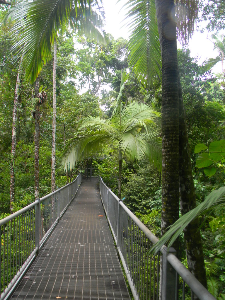
In addition to bird watching in Goomburra Forest, you can find many lookouts (with stunning views and useful illustrative panels).
I have been to look out Sylvesters which has access through a small and short path that you can reach from one of the many walks in the rain forest.
I suggest you two walks :
Sylvesters lookout ( Class 3) medium level of difficulty
Distance: 940 m (round trip)
Time: about 30 minutes of walking
Details: The Sylvesters lookout offers magnificent views over the coastal plain below, between the southern tip of Lake Moogerah and the rugged chains southern border. The track starts from Lookout Road about a 4.7 km drive from Kurrajong picnic area. During the Australian summer and generally in wet periods this road could be closed.
The second and longest walk I have done was the ” Wider Track“, 12 kilometres (6 one way).
Winder track (Class 4) High level of difficulty
Distance: 12 km total
Time: About 4 hours of walking
Details: The Winder trail starts northeast of Lookout Road, 6.3 km beyond the picnic area Kurrajong. This route passes through the rainforest along the crest of the Mistake range before ending the ‘ winder ‘, a relic of a machine that was used to deforest.

How to get there?
Unfortunately, it is not possible to reach these places by public transport, but only with the private car, possibly a car suited to mountainous and disconnected terrain, which can get you out of every unstable situation.
The Main Range National Park is 116 km south-west of Brisbane and 50 km east of Warwick.
The Highway Cunningham crosses the park at Cunningham Gap and provides access to the northern part of the park, which includes facilities for visitors and walking tracks at Cunningham Gap and Goomburra.
Access from the east to the Spicers Gap is suitable for conventional vehicles and can be reached via Lake Moogerah Road, which leaves the Cunningham Highway 5 km west of Aratula, then Spicers Gap Road.
The Spicers Gap Road ends at the parking Governors Chair.
For more information visit the official website
And do not forget the map of the Goomburra Forest Reserve.


the Boondall Wetlands Reserve is seated 20km from Brisbane city, and it is easy to reach by public transport. It is possible to get to the environmental centre in half an hour by train from Central station ( plus 15 minutes walking from Boondall station).
These wetlands are part of many wetlands recognised by the Ramsar Convention as an internationally famous area for migrator birds.
I love to walk that’s why I choose to follow the circular walking track suggested by the visitor centre: the Billai Dhagun Walking Track. Cycling and canyoning let you probably discover more about the reserve but while walking it is possible to stop have a look at plants and animals, to seat on the ground and read the interesting guide that the environment/ visitor centre lends to the tourist.
Each visit is unique and different: that’s why I cannot guarantee what you will see. It might be different from what I have noticed! I can tell you, instead of how has been my experience!
Please be aware! Bring food and water. The environment centre does not have any food and beverage service.
A very helpful guide from the environment centre at the beginning of the walk has shown another tourist 2 Tawny Frogmouth (photo below) and me on the three. They looked like had been strategically placed in those spots to welcome; however, this was only the case because this is a natural reserve, not a zoo or animal sanctuary. It made the visit very much special!
Just before the entrance of the reserve, I have discovered in a tiny pond where there were the typical Australian White Ibis and the less common White-faced heron.
The small but handy book the environment centre lend to the visitors has been created from passionate volunteers, the same people that are still involved with the reserve, that is why there are few copies, and every single visitor has to take care very carefully of it. The guide book is divided into 17 sections, my experience has been through 15 of them, but it is worth it to follow the suggestion written on it.
Generally, the different session is not indicated with signs ( a part of a couple with totems quite hidden on the path) you need to to try to understand what the guide is talking about following the descriptions.
The Environment Centre is a typical Queenslander house seated there since 1996, able to host visitors and give them information. Around 15.000 visitors per year and full of wildlife around ( birds and reptile the most common ).
Following the walking path going south, it is immediately possible to feel you are getting closer to the sea, the first sign is the different species of plants.
To get more info, please see the website: http://www.brisbane.qld.gov.au/environment-waste/natural-environment/environment-centres/boondall-wetlands-environment-centre/index.htm
The brochure in pdf is available here: http://www.brisbane.qld.gov.au/downloads/environment_waste/natural_environment/boondall_wetlands_brochure.pdf
I am going to let my photo to guide you through the path, just to give you an idea about the reserve.
Australian magpie

Uneucalyptus siderophore (grey ironbark)

Kangaroo Totem

Coast she-oak

The Path to Bird Hide

Pelican from Bird Hide, Mangroves and Saltmarsh

Pelican from Bird Hide, Mangroves and Saltmarsh

seen near the Boardwalk

Speaking about Sustainable tourism in Australia the experience at Skyrail rainforest cableway has been amazing, I have visited Skyrail in January 2014. I have found the experience very interesting and breathtaking even if at the beginning I did not understand completely how it can be considered so much sustainable and I was curious to see it in person.
The visit took some hours. I have started the tour with the regular gondola at midday and I finished it around four. It has been a very short visit and I wish I could have more time to stay but at least it was enough to enjoy my time there. The gondola is absolutely stunning, there are no photos that can express how magnificent it was, but I want to give you an example with some of the photos I have taken.
The best view is from the tower n 18 to 25 because this is the closest you get to the rainforest canopy. These towers are seated between the two intermediate stops, the so-called Red Peak and Barrow Falls.
The first stop is Red Peak Station where there is a rainforest boardwalk and a short guided tour waiting for you every hour.
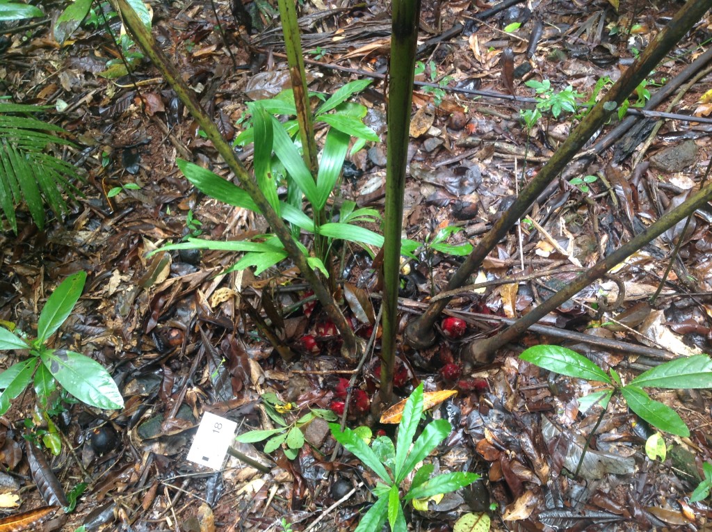
Lush rainforest surroundings at this station invite to take a closer look at the diverse array of plant species, including the towering 400-year-old Kauri Pine.
The second stop is Barrow Falls Station where there are tree lookouts from where is possible to enjoy the view of the majestic Barrow Falls and the Barrow Gorge. At this stop, it is also seated the interactive Rainforest interpretation Centre that helps you to discover the fascinating history and evolution of the Wet Tropics World Heritage area.
Kuranda, the Village in the Rainforest, boasts numerous attraction including a butterfly sanctuary, bird aviary, koala park, art galleries, cafes, restaurants and the famous art and craft market. In Kuranda is also possible to walk, unfortunately, I did not have much time and I could not experience Kuranda, I will certainly do it better next time.
During the visit, I have started to understand a bit better why it is considered sustainable, at least from an economic and social point of view, but I had still some doubt about the ecological point of view I needed to check.
There is only one rule here on sustainable tourism world which tells you the truth, I have to admit after the visit I could not share immediately about Skyrail because I wanted to be sure why they are considered very sustainable, they won awards. To answer all my questions I had to do some research and I am ready now to share what I have discovered.

The sustainability – what is behind the trip, what makes Skyrail rainforest cableway the most environmentally sensitive cableway project in the world?
– The Construction process
– Education (basic and more specific options)
– Researches founded by the Skyrail foundation
Today I am going to tell you about the construction process, but stay tuned to get more info soon.
[wpspoiler name=”The Construction process” ]The original Skyrail concept was conceived in 1987 and was followed by 7 years of pre-construction feasibility studies, an Environmental Impact Study and numerous other reports and assessments, and consultation and approval processes with local, state and federal governments and local communities.
Construction commenced in June 1994.
Skyrail’s tower sites were selected to coincide with existing canopy gaps and were surveyed to ensure no rare, threatened or endangered species would be affected by construction. Before construction commenced on the tower sites, the leaf litter and topsoil was collected and stockpiled for reintroduction when construction was complete. Plant seedlings were catalogued at each site, then removed and propagated during construction, and re-planted in their original locations, with the saved topsoil and leaf litter, when construction was complete.
The towers were constructed in 10-metre x 10-metre clearings and were placed as far apart as mechanically possible. The tower footings were built largely by hand, up to five metres deep in some cases, using picks and shovels.
There were no roads built during Skyrail’s construction. Workers had to walk into the remote tower sites each day, carrying their equipment, which took up to an hour each way.
The Red Peak and Barron Falls Stations were designed to blend in with the surrounding rainforest surroundings and minimise environmental impact and were built in pre-existing clearings. Skyrail opened to the public on 31 Aug 1995.
In December 2013, Skyrail introduced 11 Diamond View glass floor gondolas which seat 5 people and offer yet another amazing perspective of the rainforest below.
Stretching 7.5km, Skyrail was the world’s longest gondola cableway at the time of completion. More importantly, Skyrail provided people with a unique opportunity, and a world first, to see and experience the rainforest in a safe and environmentally friendly way.
The Skyrail project and construction required world-first construction techniques and even today Skyrail Rainforest Cableway remains the most environmentally sensitive cableway project in the world.[/wpspoiler]
What makes Skyrail rainforest the most environmentally sensitive cableway, how it can be considered so much sustainable and I was curious to see it in person.
Further information about the visit: Skyrail Rainforest Cableway a great way to experience the rainforest in Cairns
After the tour and some research, I discovered that Skyrail rainforest cableway is the most environmentally sensitive cableway project because of
– The Construction process
– Education projects and opportunities
– Researches and studies sponsored by the Skyrail foundation
[toggle title= “The Construction process”] The original Skyrail concept was conceived in 1987 and was followed by seven years of pre-construction feasibility studies, an Environmental Impact Study and numerous other reports and assessments, and consultation and approval processes with local, state and federal governments and local communities.
Construction commenced in June 1994.
Skyrail’s tower sites were selected to coincide with existing canopy gaps and were surveyed to ensure no rare, threatened, or endangered species would be affected by construction.
Before construction commenced on the tower sites, the leaf litter and topsoil was collected and stockpiled for reintroduction when the installation was complete.
Plant seedlings were catalogued at each site, then removed and propagated during construction, and re-planted in their original locations, with the saved topsoil and leaf litter, when the installation was complete.
The towers were constructed in 10-meter x 10-meter clearings and were placed as far apart as mechanically possible. The tower footings were built mostly by hand, up to five meters deep in some cases, using picks and shovels.
There were no roads built during Skyrail’s construction. Workers had to walk into the remote tower sites each day, carrying their equipment, which took up to an hour each way. The Red Peak and Barron Falls Stations were designed to blend in with the surrounding rainforest surroundings and minimise environmental impact and were built in pre-existing clearings.
Skyrail opened to the public on 31 Aug 1995.
In December 2013, Skyrail introduced 11 Diamond View glass floor gondolas which seat five people and offer yet another fantastic perspective of the rainforest below.
Stretching 7.5km, Skyrail was the world’s longest gondola cableway at the time of completion. More importantly, Skyrail provided people with a unique opportunity, and a world first, to see and experience the rainforest in a safe and environmentally friendly way.
Project and construction required world-first construction techniques and even today Skyrail Rainforest Cableway remains the most environmentally sensitive cableway project in the world.[/toggle]
[toggle title= “Education projects and opportunities”]Education projects and opportunities”] While visiting Skyrail, I discovered if you are a group, it is also possible to attend different kinds of education programs such as Skyrail’s Interpretive Ranger Option, Skyrail nature link, Skyrail’s Sustainable Seminar, Skyrail’s Rainforest Link and The Ed-Venture Guide.
Skyrail’s Interpretive Ranger Option allows your group to enjoy a personalised Ranger-guided tour through Australia’s World Heritage protected Tropical Rainforests, with focused nature guided tour at the Red Peak and Barron Falls stations.
Skyrail nature link During Nature Link’s specialist presentation, one of Skyrail’s Rangers will share their knowledge of these ancient forests in a friendly and interactive lecture-style delivery. Groups will have the chance to ask questions and view a stunning selection of visual images and specimens of rainforest flora.
Skyrail’s Sustainability Seminar provides groups with an understanding of sustainable tourism and how a tourism operator conducts its business to meet these principles. The seminar will be presented by a Skyrail Ranger or senior manager, who will engage the group in a 40-minute informative discussion about Skyrail’s sustainability vision and its continual improvements made since inception. Participants will have the opportunity throughout the seminar to ask the presenter questions.
Skyrail’s Rainforest Link involves groups in a rainforest regeneration project, providing a ‘hands-on’ rainforest experience while teaching the importance of Australia’s Tropical Rainforests. Accompanied by Skyrail’s Rangers, guests plant a native tree in Skyrail’s rainforest regeneration corridor. When completed, the tree corridor will link the freshwater lake at Skyrail’s Caravonica Terminal with the nearby rainforest, providing a safe passage to water for a variety of native birds and animals.
For school groups, Skyrail offers its very own Ed-Venture Guide which illustrates Skyrail’s commitment to education and contains extensive information on the rainforests, their World Heritage listing, their environmental and global importance and unique rainforest flora and fauna. [/toggle]
[toggle title= “Researches and studies sponsored by the Skyrail foundation”]

The Skyrail Rainforest Foundation was established in 2005, with the primary objective of raising and distributing funds to support tropical rainforest research and education projects.
Their vision is: “The protection of tropical rainforests worldwide through sound management, understanding and appreciation through research and education.”
The Skyrail Rainforest Foundation supports tropical rainforest research and education projects that meet the Foundation’s objectives. The funding will favour projects with a specific focus on the resilience of tropical rainforest ecosystems and livelihoods, within the foundation objectives of supporting:
• Pure research aimed at understanding rainforest flora and fauna, ecosystems processes and biological interactions
• Applied research aimed at improved management and use of rainforest environments around the world
• Education and communication to enhance global understanding and appreciation of tropical rainforest environments, contributing to greater awareness and improved management and protection
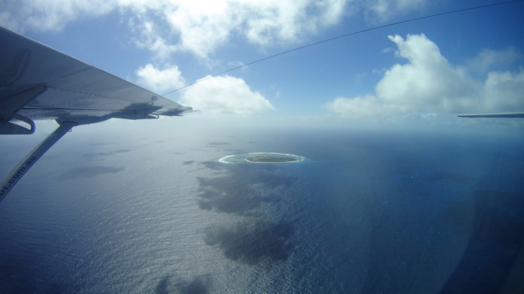
I am sure I will remember this experience at Lady Elliot Island forever, as an experience of what can be considered sustainable tourism in Australia. The day has started with a short flight with a tiny aeroplane (if it is possible to call it this way) with only 13 seats on it.
The flight was tranquil, a short time after flying over the ocean we started to see Lady Elliot, this was the exact moment I began to fall in love with this little pearl of the sea, even more than on the ground, before doing snorkelling on its coral reef, before having rested on the beach.
Immediately we discovered we were not alone, Lady Elliot Island is one of the most significant seabird breeding sites in the Great Barrier Reef World Heritage Area (UNESCO), and it is the southern-most extent of many species’ breeding distribution. Large numbers of seabirds can be found at this site between October and April each year. Although around 57 species can be found on Lady Elliot Island through the year, only approximately 14 of these species use the site for breeding. Some of these species include black and common noddies; black-naped, bridled, crested, roseate and sooty terns; pied and sooty oystercatchers; wedge-tailed shear-waters, silver gulls and the threatened red-tailed tropicbird. (thanks Lady Elliot Island website for the info click here to read more).

After a short meeting with the staff my friends and I decided to start snorkelling in the eastern side of the Island, as suggested from the team, it was a bit windy, and during the afternoon this side can be more difficult to snorkelling in because of the tide too.
The lagoon is in general ideal for novice snorkelers (tide dependent) and full of tropical fish, colourful coral, sea cucumbers, starfish, sea urchins, clams and turtles.
After a delicious but light lunch and a walk around the Island we joined one of the daily glass bottom boat/guided snorkel tours, this excursion was much more comfortable than the first one because we had the chance to jump from the ship which is (in my opinion) much better than the entrance straight off the beaches. No sharks for us but only adorable and cute fishes, turtles and corals.We have been so lucky not only to swim with a turtle but also to see a massive manta under our glass-bottom boat. I have to share Lady Elliot Island is collaborating with a project from the University of Queensland, Brisbane about mantas: http://www.ladyelliot.com.au/content/project-manta-0 .The plans were founded in 2007 to investigate the population biology and ecology of manta rays in eastern Australia. Photo/Why Is Lady Elliot Island the right choice if you like to do sustainable tourism in Australia?
Because they have an Eco-Resort, an Environmental Policy, Environmental Protection and Eco Initiatives
Eco Resort, The Lady Elliot Island Eco Resort, is dedicated to the preservation of the natural environment of the Great Barrier Reef. Island Management has reduced energy consumption and carbon emissions by introducing a combination of solar and gas technology, water desalination and various strategic behavioural adaptations on the Island. They have developed the first dedicated Climate Change Trail and Tour around the Island to highlight the impacts that climate change could have on a coral cay ecosystem. If you like to find out more about what the manager Peter Gash and the staff do to offer a more sustainable tourism click here (http://www.ladyelliot.com.au/content/eco-resort )
Environmental Policy the fully complete environmental policy can be found on Lady Elliot Island website In http://www.ladyelliot.com.au/content/environmental-policy
Environmental Protection Lady Elliot Island is a National Park and Marine National Park, ie. A ‘Green Zone NO TAKE’ area and therefore has numerous minimal impact regulations that must be followed. Please visit Lady Elliot Island website to read the complete list. http://www.ladyelliot.com.au/content/environmental-protection
Eco Initiatives more info at www.ladyelliot.com.au/content/eco-initiatives
– We generate power utilising our state of the art Hybrid Solar Power Station, which combines the technologies of solar panels, gel batteries, inverters and a generator to supply 3 phase power to the Island.
– The fuel, gas and other energy sources come from Gladstone by barge every three to four months.
– The freshwater is created by a Dunlop IBC reverse osmosis desalination system, converting seawater to clean water at a rate of 25 litres per minute.
– Our wastewater/greywater is treated in an AdvanTex wastewater treatment plant and is used for irrigation of the airstrip
– All of the fresh fruit, vegetables, other food items and beverages come to Lady Elliot Island by aircraft, and all food waste is composted in a pit system.
– Solid waste material and petroleum-based oil wastes are removed by barge to approved facilities on the mainland
Sustainable Tourism IN Australia: up north discovering Daintree Rainforest (Daintree National Park)
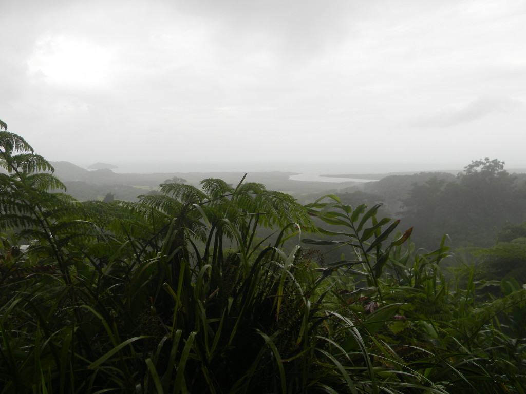
There is nothing better than discover the beautiful Queensland doing sustainable tourism, I have been so lucky to have the chance to visit Daintree National Park during the time I was working in Brisbane.
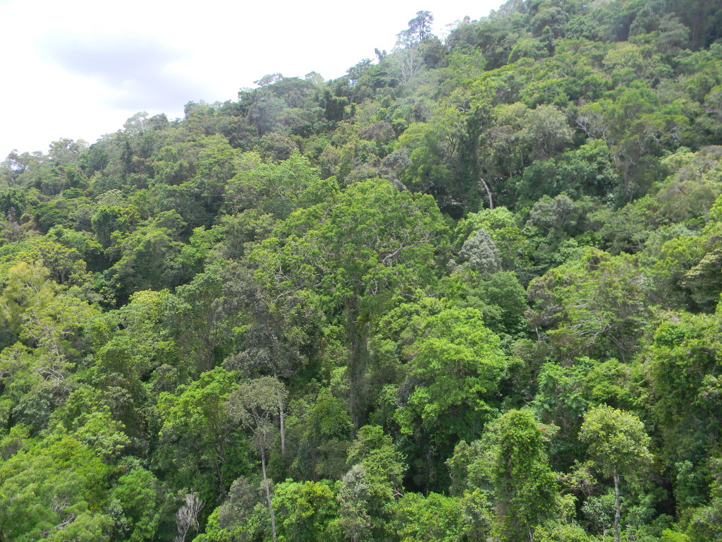
The Daintree rainforest is one of the oldest and most beautiful forests I have ever seen, actually, it is the oldest intact tropical rainforest in the world. The region referred to as ‘The Daintree Rainforest’ covers an area of approximately 1,200 square kilometres, from the Daintree River north to Cooktown and west to the Great Divide, representing the single largest block of tropical rainforest in Australia.
The Daintree is one of the few places in the world where the rainforest meets the reef! But it is its antiquity that really sets it apart. Just to put that into context:
– the Amazon is about 7 million years old
– the Kuranda Range – (Queensland near Cairns) 60 – 70,000 years and
-the Daintree is thought to be between 110 – 200 million years old
This tropical rainforest ecosystem is one of the most complex on earth. Its plant diversity and structural complexity is unrivalled on the Australian continent and represents the origins of many of Australia’s most familiar flora.
First stop: Cape Tribulation (where the regular route stops).
Cape Tribulation is an amazing area immersed into the rainforest where to stop for the night, there you will find a different kind of accommodation, but if you are travelling by camper or campervan I can suggest you PK’s Jungle Village the only low budget accommodation in this area. We stayed there only for one night and it was fine and funny.
Daintree National Park and Daintree Discovery Centre
If you are around you cannot miss the Daintree Discovery Centre, it provides an excellent introduction to this ancient rainforest. Opened in 1989, it is a self –funding, private enterprise. Entry fees support the ongoing development of the Centre including the DDC Carbon Offset Program.
The Centre is recognised as a leader in the field of ecotourism, they have been awarded the Advanced Eco Tourism accreditation. The centre is very interesting and the audio guides allowed us to discover a bit more about this incredibly beautiful place.
There are several options to discover the rainforest:
– the aerial walkaway is spectacular, it is wheelchair friendly and allows safe and easy access to the mid-level rainforest;
–the canopy tower provides the most amazing insight into the surrounding rainforest, from the forest floor to the uppermost reaches of the canopy. It is a cyclone rated and has 5 large viewing platforms.
–elevated Boardwalks allow you to thread their way through the lush, unspoilt rainforest to see, smell and experience the rainforest, while at the same time protecting the fragile root systems of the forest.
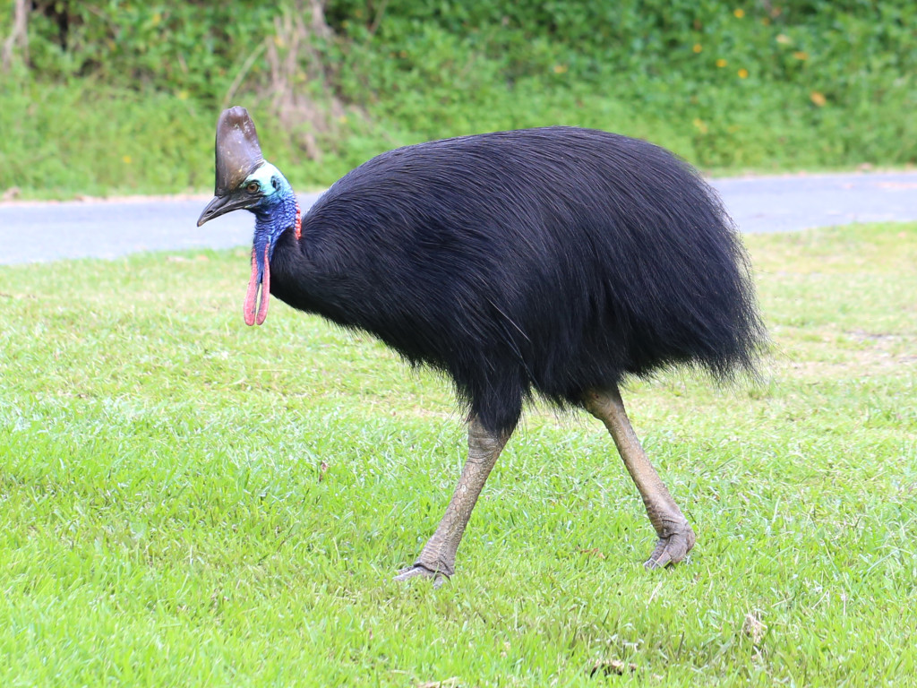
The cassowaries are ratites (flightless birds without a keel on their sternum bone) in the genus Casuarius and are native to the tropical forests of New Guinea, nearby islands, and northeastern Australia.[2] There are three extant species recognized today. The most common of these, the southern cassowary, is the third tallest and second heaviest living bird, smaller only than the ostrich and emu. Cassowaries are very shy, but when provoked they are capable of inflicting injuries to dogs and people, although fatalities are extremely rare.
Cassowaries are predominantly frugivorous. Besides fruits, their diet includes flowers, fungi, snails, insects, frogs, birds, fish, rats, mice, and carrion. Fruit from at least 26 plant families has been documented in the diet of cassowaries. Fruits from the laurel, podocarp, palm, wild grape, nightshade, and myrtle families are important items in the diet. The cassowary plum takes its name from the bird.